Wednesday, 2 November 2011

Town hall services move across the A501

Living Streets Kings Cross group members are concerned that the Transport Strategy for B3 has not properly prioritised or addressed the planning of safe and enjoyable walking, cycling and public transport access for people approaching the council offices (B3) via the public highways onto which this building fronts.

Our group was alerted by a local campaigner Lee Baker to the possibility of commenting on the new Camden borough offices in King's Cross, which will move from Bidborough Street across to King's Cross Central "building B3" to save money. We thought this would reduce the accessibility of the Camden services building on foot and by bicycle, despite this being a brand new building in the King's Cross funded by Camden as a tenant. We wrote the following deputation statement for Thursday Evening's Planning meeting:

Deputation Statement on 3 Pancras Square (Planning Application 2011/4090/P Plot B3, 3 Pancras Square)

Living Streets Kings Cross group promotes and campaigns for safer, more enjoyable streets where we work and live in King’s Cross, in the vicinity of King’s Cross Station. Living Streets King’s Cross group requests that
Camden - through planning obligations (section 106) agreements - make its future offices highly accessible to the walking, cycling and public-transport-using public, including all ages and abilities, and including newly arrived international passengers. Living Streets Kings Cross group asks that Camden ensure that surrounding streets are measurably safer and more pleasant to use than those currently existing and planned, in keeping with Camden's Planning Strategies, and that Camden planners make it safer and easier to walk to new Camden offices at Pancras Square, especially, to make it safer and more pleasant crossing under the station tunnel, from St Pancras Station, from Pancras Road, from Camley Street, from Goods Way and from Euston Road.

The planning obligations (s106) associated with outline planning consent in 2008 for King’s Cross Central were that the streets would be safely walkable and easy to cross for diverse pedestrians and cyclists, connecting the entire Kings Cross Central area with the remainder of the borough, north, south east and west. Planning consideration has now been narrowed to the footways onto the roads outside B3. We are concerned about a reference in the current planning submission to new bus and coach drop-off facilities at B3, to avoid 'road crossing' (6.62) and would conflict with core strategy and with pedestrian, public transport and cycle access. The bus bays would therefore replace the existing safe walking access for schools and other groups to the Council offices currently available in
Euston Road with unnecessarily motor-vehicle-dependent access. This contradicts Camden's strategic plans for improving walking, pedestrian and cycle accessibility, air quality and the environment (Core Strategy Document CS11, CS13).

The cosmetic junction improvements (‘extended pedestrian island’) planned by TfL London Streets for 2011-12 at Euston Road and Pancras Road junction seem pitifully inadequate to address the 2008 safety report UPR/T/029/08, and will be obsolete for the 2012 Olympics and when B3 is complete. There are no improvements proposed for crossing the dangerous junction of
Camley Street, Goods Way and Pancras Road in front of B3 where Emma Foa was killed. (See 2008 report) (see also page 47 of public reports pack)

Camden’s recent cosmetic (s.106 funded) improvements to York Way are already obsolete, and the road remains unnecessarily unsafe. Group members are concerned that Camden is not planning these public areas including Pancras Road, Camley Street, Goods Way to be effective, pleasant or sufficiently safe, and that planning for these areas should be of a coherent and excellent international standard, rather than piecemeal and inconsistent.

The walking and cycling access standards for proposals for B3 and Kings Cross Central are not in accordance with the Kings Cross Place Plan developed and agreed by
Camden with the community (Matthew Furness et al). The group requests that pedestrian and cycling access standards be of an international standard befitting such an internationally significant location. The current standards are compromised and inadequate.

In all, Living Streets Kings Cross group members are concerned that the Transport Strategy for B3 has not properly prioritised or addressed the planning of safe and enjoyable walking, cycling and public transport access for people approaching the council offices (B3) via the public highways onto which this building fronts.

~

Friday, 28 October 2011

DIY King's Cross

It is increasingly apparent that agencies - LB Camden, LB Islington, Network Rail and Transport for London - are reluctant collectively to make King's Cross streets in the area around this internationally unique transport hub into a safer and more pleasant set of places to live and work.

One possibility for the holistic redesign of the area as a circulation system is not to leave it to 'fall between the stools' of these various agencies with their separate bureaucratic problems and resource limitations but to drive the process through a local group pf stakeholders.

The process could be modelled on what Sustrans calls DIY Streets :
http://www.sustrans.org.uk/what-we-do/liveable-neighbourhoods/diy-streets 

 and the 'Placecheck' method could be used for basic assessment of the streets.

Friday, 21 October 2011

Placeshaping - Shaping future King's Cross

King's Cross Placeshaping Workshop (20 Oct 2011, hosted by LB Camden Placeshaping, at the Camden Centre in the Town Hall)

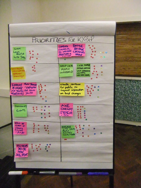
This short list (pictured) of priorities for the future of King's Cross was assembled, all in response to the draft from October 2010 workshops and more recent documents drafted by LB Camden (pdf). Each group represented communicated its issues for the Vision for King's Cross. These were prioritised for importance and for desired engagement with 'Camden Placeshaping team'.
(Following an an unsuccessful touchy-feely draw a crest exercise)

The red dots here indicate partcicpants votes for importance of issue (12 dots per participant allocated as they wished)
Coloured Stars show the groups' desired (voluntary) resource commitment to each issue - except that police are not voluntary (9 per participant allocated as they wished)

Looks like the gyratory is of key importance, but then, that was clear years ago. Safety in the public realm on the (motor) traffic system which forms the armature of this urban area is unsurprisingly fundamentally important, especially in light of recent casualties on it.

Howewer, it seems that Camden does not have it within its scope or capacity to influence this, nor even to ensure that its planning requirement for public access across King's Cross station ("Battle Bridge" - top right) can be upheld against Network Rail, which now considers it unnecessary.

Greg

Attendees:
Participating Residents / Consultees: 7
representing:
Living Streets King's Cross 1 (Greg)
King's Cross Development Forum 1
Camden Square Neighbourhood Association 1
Camden Community Radio 1
The Calthorpe Project 1
King's Cross Brunswick Neighbourhood Association - Youth Services 1
Resident and Lib Dem Campaigner Lee Baker

Participating police officers in uniform: 2; PC Jonathan Oran, Sgt. Gary McGovern

Non-participants
Council Officers: 5
Facilitators: 2

There was an undertaking that Placeshaping document draft would be redrafted with these priorities and resources in mind, with Head of Shaping Services "Helen" and Matthew Furness leading at LB Camden. The exercise seemed to revisit many issues from the October 2010 workshop.


Monday, 17 October 2011

King's Crossings

Should there be a connection between King's Cross Square and King's Cross Traffic Gyratory? There is one already, in that many users of the stations cross the roads in order to use the surrounding area; shopping, residing temporarily or permanently, working, going to entertainments and recreation, etc.

Motor vehicles on these busy roads, which are part of the "arterial" and "ring road" road transport systems "A501" and "A5200" have had a history to date of dangerous and violent physical contact between users of the road , and also produce noise, pollution and an arguably anti-social effects every day for the ambiance of these public spaces, and affecting the people who visit or live in the area, and those who work in or visit shops and businesses in the area.

The licensed operators of heavy vehicles are not personally responsible for the environmental impacts of these vehicles, and even in a conflict or deadly accident, may be exonerated as merely 'inadvertent'. Does the responsibility for care of these public realms rest solely with the collective publics, then?

One part of King's Cross' the public realm here, the square, is managed by Camden/Network Rail/King's Cross Redevelopment, however another, the roads A501 and A5200, are managed exclusively by Transport for London.

King's Cross is currently the focus of local debate about traffic danger on junctions which could be potentially far safer and far more pleasant to walk through (and even to shop in). King's Cross Square is the subject of recent discussion about (privately funded) public art in this prominent London public space, where even the responsibility for maintaining dangerous icy pavements in front of bus stands is ambiguous.

Could these public realms be more harmoniously connected? Could there be a better balance between pedestrians and vehicles in these important spaces, despite the Mayor's preoccupation with (motorised) traffic, in line with Transport for London promoting walking and cycling?


new from King's Cross Environment

More on the call for a corporate manslaughter claim here in the Guardian Bike Blog.
Response in Drawing Rings Around the World blog with some useful data like this:


Imminent workshops on the King's Cross Place Plan  - although unlikely to address the Camden-Islington separation, may be another opportunity to discuss some of these issues about managing the public realm in King's Cross. rsvp!

Thursday, 13 October 2011

Wild Food

King's Cross Forage
Wild food walk - foraging on a radius around Camley Street Nature Reserve on a two hour walk, we found innumerable things growing in unexpected nooks by roads, along the canal, in ambiguous abandoned parts of road reserve, and on housing estates.
Six of us set off on a Thursday morning with a long forked birch stick, some books to identify species, a bucket and a blanket.

Some of our locations and finds included;
St Pancras Station road reserve on Pancras Way - a variety of nettles


At London's newest large street, King's Boulevarde, we found Plane Trees, and spoke to a keen street warden, and discussed the potential for guerilla planting some edible plants on the Boulevarde where Eat Street was setting up for the Central St Martin's students...


Grapes near Battlebridge Canal Basin

Local fishermen were catching (small) fish - mentioning pike, perch, dock, bream.


King's Cross Wild Grapes!


Many salads, including rocket and nettles were discovered, and flowers, like miniature Daisies... on the towpath


Blackberries were found growing on Goods Way, opposite the old Petrol Station


Cherries in Fyfe Terrace
Pears in Killick Street


A bucket of large apples was collected from trees in Birkenhead Street - shared with residents, and for Rubies in the Rubble..
Cherries in Judd Street....
Now to wash and process everything!

 page 1

 page 2


Addendum 24 October
Map to print double sided on A4 and fold to pocket-size!
Great Work Jeannine and friends